In Marion County, “there are many gentle slopes and small elevations in and around [Indianapolis], but nothing that deserves the name of hill, except Crown Hill…and one or two smaller protuberances a mile or two south.” While this observation in the state geologist’s report gave the official topography of the county, there were other “hills,” maybe less grand, but no less popular for play and recreation, and even sites of memorable events.
High ground five miles east of the Hoosier capital, that would later be known as Brown’s Hill, was a gathering place for hundreds of faithful followers of Massachusetts prophet William Miller in the spring of 1843. From his study of the Bible and after applying mathematical calculations to the prophecies, Miller predicted the end of the world in April 1843. The appearance of a great comet in March seemed to many a confirmation of the prophecy, and on April 1, 1843 the local Millerites donned their white robes and marched east along the National Road and across Pleasant Run to take their position atop the “highest point east of the village.” The day was spent in “prayer, praise and exhortation,” but when the lengthening shadows gave way to nightfall and nothing had happened the faithful “sorrowfully” made their way back to Indianapolis. Fifty years later, Indianapolis newspaper man Hilton U. Brown built his house on the hill and for decades to follow Brown’s Hill, at the southwest corner of east Washington St. and Emerson Ave., was the site of children at play and community sledding in the winter.
Southwest of Brown’s Hill, across the Pleasant Run flood plain, rises Violet Hill, today the site of Thomas Carr Howe High School. The hill received its name from Hilton U. Brown, Jr. who, as a boy, roamed the tree-lined banks of the creek and wild fields beyond, collecting violets on the slopes of the hill in the springtime. After Howe opened in 1938, an annual May Pageant of Achievement was held on the terraces below the tower presided over by the Violet Queen.
Nearby, Washington St. and the roadbed of the former Pennsylvania Railroad cut across another piece of high ground known as Mt. Salubria that rises east of Sherman Dr. North of the road, Former Marion County sheriff and Indianapolis mayor John Wallace had a “splendid brick residence” built in 1865 at 4704 E. Washington St. that later became the home of the Bosart family. A short distance south of the National Road, the railroad grade was so steep as it traversed Mt. Salubria that two locomotives were used to move outbound freight trains “to the summit of the hill.”
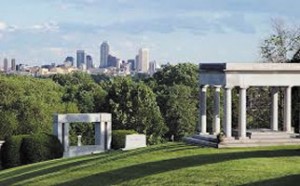
What was believed at the time to be the “highest elevation of Marion County” was laid out in 1863 as Crown Hill Cemetery. Among the four farms purchased by the Crown Hill Association for the cemetery was one owned by Martin Williams on the slopes of Strawberry Hill, so named because it was “covered in season with the finest and largest strawberries in this part of the country.” In 1916 when James Whitcomb Riley died, the “crown” of Strawberry Hill was where the Hoosier Poet was laid to rest beneath a simple marble slab enclosed within a classical open-air structure supported by ten Ionic columns. Over the years, visitors to Riley’s tomb have seen the growth of Indianapolis from a vantage point that offers a spectacular view of the city.
Today, across Michigan Rd. (Martin Luther King, Jr. Blvd.) from Strawberry Hill, fronting the canal, is Golden Hill, an exclusive residential neighborhood and historic district. In earlier times, Golden Hill encompassed a larger area known as Armstrong Park and was a popular picnic site with beautiful forest trees, accessible either by land or on the canal by canoe or a boat ride. “A dancing platform and other attractions” including “Camp Delight,” the name given by campers, drew people to this favorite resort.
Extending east of Millersville along the south bank of Fall Creek is a range of hills that extend into Ft. Benjamin Harrison State Park. The highest hill in this wooded range is Mt. Nebo, and “from its summit one commands a view of great beauty.” Although the site was some distance from Indianapolis and difficult to get to in earlier times, Mt. Nebo was popular with picnickers. Today the “mountain” is part of Brendonwood, an historic neighborhood designed by noted landscape architect George Kessler. Another part of the bluffs overlooking Fall Creek is Buzzard’s Roost, which today is on the west side of I-465 and is known as Woollens Garden. The 44-acre site was acquired in 1897 by William Watson Woollen and kept “in its wild condition” as a place for nature study. Woollen gave this “tangled wood” to the Indianapolis park board in 1909 as a botanical and ornithological garden.
The high ground that forms the west bank of White River, over which Cold Spring Rd. runs, is marked near its southern end with a boulder and plaque commemorating the site of Civil War Camp Robinson where Col. Lew Wallace, the author of Ben Hur, trained the 11th Regiment, Indiana Infantry Zouaves, in the spring of 1861. Further along to the north at 30th St, the embankment is less precipitous but no less steep and provides the perfect course for soap box derby racing. Since 1953, the 900-foot-long blacktopped course of Wilbur Shaw Memorial Hill, named for the three-time winner of the Indianapolis 500-Mile classic, has heard the annual whoosh of soap boxers hurtling in heats three abreast to the finish line.
While Marion County may boast of only a handful of true hills, in the popular mind there are many “hills,” and yes a few “mountains,” that dot the landscape. The next time someone says the geography around Indianapolis is uninspiring, tell them to look carefully and seek the higher ground.