The unseasonably warm weather and dry streets on New Year’s Eve 2018 gave revelers an opportunity to safely party with friends in homes and nightspots. However, my co-ed granddaughter marked the passing of the old year in a more relaxed and peaceful way by taking a drive eastward to Richmond on the National Road. On her return trip to Indianapolis moments into the New Year, deep in the ebony recesses along the venerable highway an occasional illumination shot through the air bursting in a blaze of color. No descending crystal ball, no shouting of multitudes, simply the serenity of driving through the Indiana country side and quiet lights of small-town America.
For over 180 years travelers and commerce have crossed central Indiana, east to west and west to east, over the Hoosier segment of the nation’s first great internal improvement. Often referred to as the Cumberland Road in recognition of its beginning in Cumberland, Maryland, Congress provided funds for the thoroughfare that eventually spanned 621 miles across six states, terminating at Vandalia, Illinois, then the state’s capital. Extensions to the National Road were later authorized eastward to Baltimore, Maryland and westward to St. Louis, Missouri and on to the state capital, Jefferson City.
Along the route of the National Road, markers were erected at various intervals giving mileage or direction to and from cities and towns. Unfortunately, most of these historic features that once were familiar sights at the edge of the road have long ago disappeared. Also, the name of the National Road often intentionally disappeared as the gray ribbon of pavement left the countryside and entered an urban space, be it big or small. Crossing the Hoosier State, the National Road is Main Street in Richmond, Cambridge City, and Greenfield becoming Washington Street in Straughn, Dunreith, and Indianapolis. West of the state capital, the National Road is Cumberland Street in Belleville, National Avenue in Brazil, and Wabash Avenue in Terre Haute.
With the advent of the automobile, motoring enthusiasts like Carl G. Fisher, of Indianapolis Motor Speedway fame, put forth the idea of a transcontinental highway system, the Lincoln Highway, made up of local roads using uniform signage to mark a route from New York City to San Francisco, California. Coinciding with Fisher’s idea, the National Old Trails Road Association was organized to promote a coast-to-coast highway using uniform signage to mark a route following the National Road and the Santa Fe Trail from Baltimore, Maryland to Los Angeles, California. Paving the surface of the roads to make them practical for year-round use became a priority of the Good Roads Association.
The Marion County commissioners approved the laying of a six-mile concrete surface on the “National Old Trails” road extending from the east Indianapolis city limits to the east county line, and in September 1917 the first three-mile paved section was opened. Five years later in December 1922, the state highway commission bulletin contained the following announcement concerning State Road 3 (National Road): “New pavement open at Dunreith…removing last detour between Indianapolis and Washington. Continuous pavement twenty-nine miles west of Indianapolis; seven miles of construction, three and one-half miles pavement from Putnamville to Manhattan; three-mile construction, short pavement, half-mile gap, seventeen miles continuous pavement to Terre Haute and on to St. Louis, MO.” The “Good Roads Movement” was achieving miles of success.
Despite being sparsely paved, particularly in the West, the transcontinental thoroughfares proved to be popular for cross country travel, and in 1926 the United States highway system, with numbered routes, was established. Using a black numeral 40 emblazoned upon a white shield to mark the route from Atlantic City, New Jersey to San Francisco, California, U.S. 40, with the National Road as the major component east of the Mississippi River, was born. In Indiana, this meant that the National Road, known as State Road 3, would be known henceforth as U.S. 40. Quickly this coast-to-coast highway became popularized as the “Main Street of America.”
Travelers could easily follow the U.S. 40 signage along the open roads, but once they entered an urban center a keen eye had to be maintained to discern from the clustered signage on intersection pylons the favored route from among similar signage for other routes. While GPS makes travel easier today, realignments along U.S. 40 still requires a keen eye to keep to the historic route.
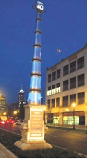
In recent years actions have been taken to mark the historic National Road across the Hoosier state. The Indiana National Road Association has installed interpretive panels at points along the historic highway, such as the one in Irvington, in addition to marking the route with distinctive signage. Since the state highway department turned over the responsibility of maintaining former highway routes within I-465 to the City of Indianapolis, travelers are now directed to follow U.S. 40 around the south half of the beltway and the historic route is no longer marked along Washington Street. However, the historic route of U.S. 40 through Indianapolis was recognized in the past few years with the inclusion of a U.S. 40 Gateway Marker as part of road improvements on East Washington Street near the city’s downtown district. The pylon is illuminated at night and lists the major cities U.S. 40 passed through between Atlantic City and San Francisco.
Some sunny afternoon, maybe a Saturday or Sunday, if you haven’t already taken a drive along the National Road, do so. If you have driven the road, do so again. Pick a section of the road and take in its romance and history. You can drive it yourself, but it’s best to take a someone with you. It’s even better to take your kids or grandkids. Don’t be rushed like you have to reach a destination; savor the countryside, savor the cities and towns, get out of the car every now and walk the sidewalks along the road, stop at a roadside picnic area. Let your senses take it all in. Enjoy the drive.