As an historian, I love maps, especially old maps — folding maps — atlases, especially atlases. I liked to flip though encyclopedias as a kid. The occasional photo was usually in black and white, so when I came across a map in color with its palette of pinks, greens, blues, and yellows it drew me in to examine all the intricate details.
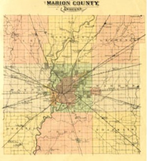
Several years ago, I discovered a wonderful atlas at the Indiana State Library — Atlas of Indianapolis and Marion County Indiana 1889. For anyone interested in local history, this atlas provides a detailed glimpse of our city and county in the closing years of the 19th century. Today, thanks to modern technology, the maps in this book may be seen on your computer.
Turning to the table of contents at the beginning of the atlas, I came across the “Index of Town Plats,” and reading the list I saw familiar names — Acton . . . Broad Ripple . . . Brooklyn Heights. . . .” Brooklyn Heights? That’s a new one, I thought. Examining the plat map and other sources, I discovered Brooklyn Heights was planned as a “model” community by Deloss Root. Its thirty-blocks were laid out on eighty acres along Crooked Creek in the northeastern corner of Wayne Township in 1873. A few lots were sold, but the area, today north of 30th St between Kessler Blvd and Riverside Park, was mortgaged and quickly fell victim to the effects of the financial Panic of 1873.
The early 1870s witnessed an unrestrained real estate boom in Indianapolis and Marion County that was reflected in the platting of Brooklyn Heights. Other plats from this period include Brightwood, Glendale, Haughville, Irvington, Julietta, Malott Park, Mapleton, Maywood, Northwood, Stratford, North Indianapolis, West Indianapolis, and Woodruff Place.
William Pattison and John A. Anderson filed a plat for Glendale in January 1873. The fifty-four lots were west of White River north of 16th St along Lafayette Rd. This proposed development also succumbed to the depressed economy. South of this failed enterprise was the manufacturing suburb of Haughville. In 1875 Benjamin F. and Joseph R. Haugh moved their iron works west of White River to Michigan St and Tremont Av. A village grew up around the works, and in December 1882 thirty-two residents filed a petition to incorporate the town of Haughville. A decade and a half later, it was annexed by the city of Indianapolis. Another successful Wayne Township village was Maywood in the southeastern corner of the township. Like Haughville, this hamlet also developed around an industry — a grist mill and a saw mill — that had been located at the site for years. Maywood was laid out on June 4, 1873, but continued to remain a small village.
On the opposite side of Marion County in Warren Township, the plat for Irvington was filed on November 7, 1870 by Jacob Julian and Sylvester Johnson. The original 108 lots were laid out along either side of the National Road and the Panhandle Railroad ran through the new suburb. Incorporated as a town on June 2, 1873, Irvington became the home of Butler University in 1875. While the “Classic Suburb” rapidly grew with the platting of new additions, its population remained stagnant until the extension of electric powered trolley service from Indianapolis and the laying of gas lines in the early 1890s. By 1900 Irvington’s population had nearly tripled. Earlier, the village of Julietta, in the southeast corner of the township, was laid out in 1868 along the Junction Railroad (CSX Railroad).
Several platted communities appeared in Washington Township during the 1870s. Malott Park was laid out in 1872 by Daniel and John H. Stewart in the eastern part of the township along the west side of the Lake Erie & Western (LE&W) Railroad. The small village had a post office, blacksmith shop and railroad station. The owners of Howland Farm, east of Fall Creek near the southeastern corner of Washington Township, called their ninety-three-acre suburb, Northwood. The Edge Tool Works had purchased the property, reserving thirty acres for its manufacturing interest, and sub-dividing the remaining lots into “splendid building lots.”
Mapleton was laid out along the township line between Washington and Center Townships in 1871. A pioneer settlement known as Sugar Grove was the precursor to Mapleton village, and a Methodist Church had been erected in the mid-1850s. In addition to the church, the hamlet had a post office, grade school, and blacksmith shop to serve the 300 residents. The community grew slowly until the extension of electric trolley car lines — Illinois-Mapleton — in 1904.
In addition to sharing a portion of Mapleton, there were five suburban communities in Center Township. North Indianapolis, located south of Crown Hill Cemetery on “high and very desirable ground fronting on Michigan Avenue, formerly known as ‘Picnic Grove’” was promoted by Alanson K. Josselyn. Platted in 1873, advertising called attention to “six large manufactories located in immediate vicinity of this addition.” A novel idea for its time allowed potential lot buyers to purchase property on “monthly installments.” In the east central part of the township, Stratford was developed east of the Belt Railroad between English Av and the Panhandle Railroad. Ads described the suburb as “comprising over one hundred acres…beautifully undulating, with Pleasant Run meandering through them.” The unincorporated suburb was memorialized in the horse-powered street railway line along English Av — the Irvington Stratford & Indianapolis Railroad Co — that was used by Butler University students. The fare was five cents to Stratford, and an additional nickel to Irvington. This suburb also failed to attain the dreams of its founders.
The industrial suburb of Brightwood was platted on September 17, 1872 and soon became the site of the “Bee Line” (Cleveland Columbus Cincinnati & Indianapolis [CCC&I] Railroad) roundhouse and shops. It was an independent town a little over twenty years, being annexed to Indianapolis in 1897. With the opening of the Union Stock Yards in November 1877, a village known as Belmont began to develop north of the pens. The residents of this hamlet filed a petition in the spring of 1882 to incorporate the town of West Indianapolis consisting of 1,565 acres lying south of the National Road on the west bank of White River. The town grew rapidly and in 1894 it achieved city status. Three years later, West Indianapolis was annexed by
Indianapolis.
Woodruff Place was to be a residential park suburb with streets divided by a grassy esplanade, with flower beds, fountains, and iron statuary when it was plated on October 2, 1872 by J. O Woodruff. Four years later it was incorporated as a town. Although surrounded by Indianapolis, Woodruff Place resisted annexation for almost ninety years, finally becoming part of the city in 1961. The “gilded age” of the suburb era was portrayed in Booth Tarkington’s novel, The Magnificent Ambersons.
Whether its speculation or the dream of a better life the success and failures of those who helped develop the place that we today call home may be found recorded on the beautiful pages of Atlas of Indianapolis and Marion County Indiana 1889.