Today we live in a world governed by numbers; from social security numbers to PINs to area codes, names are irrelevant. Even where we live is a number, beginning with street addresses and then postal ZIP codes. Thanks to modern technology and GPS, I now live at 39.7685° N, 86.0708° W. Ah, the march of civilization; whatever happened to “Steve Barnett, Irvington?” Probably at the dawn of time when our ancestors began congregating in groups, they may have identified their grass huts as being “at the Big Rock” or the “cave by the Great Falls.” Fast forward to 1787, when the few intrepid American pioneers, French residents of Vincennes, and Native Americans living northwest of the Ohio River could identify themselves living in the Northwest Territory. Within thirty years, the area was further defined with states, counties, and townships.
Five years after Indiana’s statehood, Indianapolis was laid out in the center of the state’s wilderness. By the fall of 1821, over 400 pioneers were living in the settlement and Marion County and its townships were soon organized with the first settlers staking their claims, clearing the land, and building crude cabins in the surrounding countryside.
Some features of land gave names to some settlements like Spring Valley Hill or Mars Hill in Decatur Township, Bristow’s Hill, and LeMaster Hill in Perry Township, and Johnson Hill in Lawrence Township. As land holdings large and small filled the townships, villages such as Germantown in northeastern Lawrence Township and Millersville on the Washington-Lawrence Township line were organized around mills along Fall Creek between 1834 and 1838.
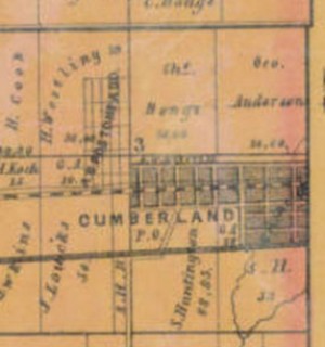
By the early 1830s, state roads and the National Road began to be cut across Marion County and a few enterprising land owners, seeing commercial opportunities, began to plat villages at strategic locations on these thoroughfares. Samuel Fullen had the village of Cumberland platted in 1831 on his land where the National Road entered the county on the eastern edge of Warren Township. A year earlier Samuel K. Barlow laid out the village of Bridgeport on the John Furnas farm in Wayne Township near the National Road’s western exit from the county. Another hamlet laid out in 1838 by Obadiah Harris along the National Road between Indianapolis and Bridgeport was Mount Jackson. Also at the beginning of the decade, the first house in Glenn’s Valley on Bluff Road in Perry Township was built by Robert Burns on whose land the village was platted.
The Michigan Road gave rise to two communities being laid out along its route through Marion County. David G. Boardman saw an economic advantage when the road cut across his land in Pike Township, and together with James Fee he had the town of Augusta platted in 1832. Along the southeast section of the road as it passed through Franklin Township, Mary Adams had J. H. Messinger lay out the village of New Bethel (Wanamaker) on her property in 1834. In the northeastern part of Washington Township, the Noblesville State Road crossed the property of John Allison and he, too, recognized an opportunity and had the town of Allisonville laid out in 1833. Major thoroughfares crossing Marion County townships continued to provide prospective town and village sites. A little settlement on Crawfordsville Road in the northwest corner of Wayne Township was laid out in 1849 by Percy Hosbrook as Mechanicsburg because many of those living there were engaged in mechanical vocations. However, the name of the village was soon changed to Clermont. In Decatur Township, along what would be known as Mann Road, the village of Spring Valley was platted in 1848 by Stephen Ward, and along what would be known as Mooresville Road, Christopher Furnas laid out the village of West Newton in 1851.
Indiana’s canal building program was the genesis for Broad Ripple and Wellington. Situated on White River, these villages were founded in 1837 on opposite banks of the Wabash and Erie Canal (Central Canal). Named for the ripple in the river at the point where it is the largest and widest, Broad Ripple’s forty-eight lots were laid out by Jacob Coil. The smaller Wellington was laid out by James A. and Adam R. Nelson and named for the Duke of Wellington.
The coming of railroads in the 1850s gave a strong impetus to the establishment of hamlets.
Two towns sprung up in Lawrence Township along the route of the Indianapolis & Bellefontaine Railroad. In 1849, James White platted Lanesville which eventually took the name of Lawrence after the post office that had been established at the crossroads on Pendleton Pike south of the town. A few miles northeast of Lanesville, the town of Oakland (Oaklandon) was also laid out in 1849 by John Emery. Two years later, Milford H. Vert platted Bellefontaine (Vertland) in the northwest section of the township along the Peru & Indianapolis Railroad. The little town of Castleton, with its nine lots, was laid out in 1852 by Thomas P. Gentry south of Vertland. Anticipating the potential for development in the central part of Decatur Township, Joe Sanders laid out Fremont (Valley Mills) in 1856. The village would later be a stop along the Indianapolis & Vincennes Railroad.
In Pike Township, William Hornaday laid out the village of Hosbrook (New Augusta) along the Lafayette & Indianapolis Railroad in 1852. In the same year, in Perry Township, William Hooker laid out the first town lots of Southport along the Madison & Indianapolis Railroad, and in Franklin Township John E. Stretcher laid out the village of Farmersville (Acton) along the Indianapolis & Cincinnati Railroad. Popular Grove and Gallaudet were also laid out along this railroad, but these hamlets did not develop beyond being railroad stops and brief post offices.
Placing a post office in a village or town not only officially confirmed the locality’s place name, but it also contributed to the economic growth of the community. While the first postmaster in Indianapolis had been named in February 1822, it was not until villages in the outlying areas of Marion County began to be platted that these communities received more convenient local mail service. Bridgeport had a post office by 1833, but in other parts of the county early post offices were little more than a crossroads designation like Piketon Post Office on the Lafayette Road which was the farm house of Adam Wright. Regardless whether it was in a town, village, or hamlet, the post office conveyed an identity to people living nearby. Everyone had “a place to call home.”